Asia · Solo Travel
Solo traveller · 15 min read
Region Kumaon, Uttarakhand, India |
Trip length 3 days, Dharchula to Om Parvat |
Travel style Solo, homestay-based |
The Adi Kailash Yatra is genuinely worth the wait, Gauri Kund and Parvati Kund especially. Budget 3 to 4 days from Dharchula covering Gunji, Nabhi, Adi Kailash, and Om Parvat, an Inner Line Permit and medical fitness certificate are mandatory throughout, and roads range from genuinely good to rough depending on the stretch, so don’t expect to move fast even when the distances look short.
Dharchula opens this whole journey right on the bank of the River Kali, the same river locals call Mahakali, with Nepal visible on the opposite bank, close enough that a bridge is all that separates the two countries. I stayed in the KMVN compound, woken by a proper river view from the balcony, and set off from there toward Adi Kailash with snow already falling on day one.
Dharchula to Gunji: The Drive Itself
Twenty kilometres in without noticing, the roads genuinely good through this early stretch. Where River Kali meets the Dhauli Ganga is worth the stop on its own, I always end up lingering at river confluences longer than planned. Breakfast happened in Pangla village, aloo paratha, a spiced potato curry, and Lobia, black-eyed peas, alongside a Kumaoni raita made with noticeably less mustard seed than the usual local style. It took just over an hour to reach Pangla, and the road stays decent for another 4 to 5km past it before turning genuinely rough again, the kind of stretch that makes the whole trip feel properly off the beaten path.
Around the 48km mark, a run of five or six mountain bends opens up one of the best views of the whole drive, River Kali tracing through the valley below under genuinely clear skies. A short detour up to Garbyang village, the largest in Vyas Valley, was worth the five-minute climb, stone houses with wood used sparingly for structural columns, roofs, and doors. Locals here split their year between staying through the harsh winter and migrating down to the plains, depending on the household. We started at 6:30am and didn’t reach Gunji until 3:30pm, though the drive itself, done without stops, takes closer to 3.5 hours. I wouldn’t recommend rushing it either way, half the point of this road is the stopping.
Nabhi and a 300-Year-Old Homestay Welcome
Gunji is the standard base for the Yatra, most people stay two nights and use it to access both Om Parvat and Adi Kailash, but Nabhi, a little further on, has developed better homestays over time, which is why I ended up there instead. Mahakali Homestay, run by a family whose welcome genuinely stopped me, a traditional greeting with a mark of crimson powder applied to the forehead as part of the ceremony, in a building that’s stood for 250 to 300 years. ₹1,500 per person got me a five-bed room, breakfast, dinner, and tea included, a proper western-style bathroom attached. Rooms here are booked bed-by-bed rather than by the room, standard practice this far into the mountains, and I ended up taking an extra windowless room upstairs purely to spread out the luggage I couldn’t reasonably carry further.
Gauri Kund: A Six-Year Wait, Finally
6am start from Nabhi, following the Kutiyangti River for what becomes a 36km stretch toward Jolingkong, from where Adi Kailash itself comes into view. The scenery shifts dramatically within just a couple of kilometres at points, the river running almost level with the road at one stretch, cold enough to genuinely startle you if you dip a hand in. Kuti, the last village in this part of the valley, sits surrounded by Bugyal meadows, grazing sheep, and mountains that stayed cloud-covered the whole time I was there, snow falling steadily by this point in the day.
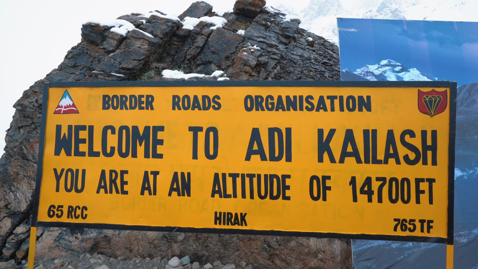
From near the base, it’s a 2.5km trek up to Gauri Kund, a Shiva temple sitting at 14,700 feet, known in English as Snow Out Point. Short, deliberate steps at a slow pace is genuinely the only way to manage the altitude here, and I found myself walking directly in the footprints ahead of me for most of the second kilometre. I’d wanted to make this exact trip since the Adi Kailash Yatra opened up roughly six years ago, and standing at Gauri Kund, the pond itself set in front of the temple, genuinely emptied my head of every thought I’d been carrying. Legend holds that Lord Shiva and Goddess Parvati took a holy dip here after their marriage, with family members following after them, and whatever you make of that, the place itself earns the reverence people bring to it. The descent, 2.5km back down over increasingly slippery ground, isn’t one I’d recommend filming, better to just watch your footing.
Parvati Kund and Bhim ki Kheti
Two routes lead to Parvati Kund from here, one via the base camp, the other a direct diversion that saves real distance, though the base camp route is the easier walk of the two. Along the way sits Bhim ki Kheti, a waterbody with weed growth locals don’t eat, tied to a local belief that Bhima himself once cultivated fields here. A 60 to 70 metre elevation gain left me properly breathless before Parvati Kund itself came into view, the trek’s original starting point visible from the opposite side, the whole layout of the journey suddenly making sense at once.
Fencing keeps visitors back from the water itself, and Goddess Parvati’s temple sits a further half kilometre on. I prayed there, and joined a small group already chanting Shiva hymns, genuinely one of the better unplanned moments of the whole trip. I couldn’t record the chanting itself for copyright reasons, but standing outside the temple as the light snow turned to drizzle is exactly the kind of moment that doesn’t need footage to stay with you.
Kala Pani, Om Parvat, and Lipulekh Pass
Gunji sits just 4km from Nabhi, a 7 to 8 minute drive on decent road, and I went back specifically for the river view and to visit Kala Pani temple, considered the source of River Kali. Local belief holds the river touches Goddess Kali’s feet before beginning its journey proper, and the water genuinely emerges from underground here, flowing from the Indian side for roughly six months and the Nepal side for the other six as the valley dries seasonally. A circular hole in a rock outside the temple marks where Ved Vyasa is said to have meditated, the surrounding Shiv Kund considered just as old as the river’s origin point itself. Hanuman Parvat, a mountain whose shape locals read as resembling Hanuman’s face, and the cloud-covered Sesh Nag Parvat both sit within view from here.
A small souvenir shop near the temple had a genuinely useful find, a two-piece separable jacket rated for -10 to -15°C, wearable as one heavier layer or split into two, priced at a reasonable ₹3,000. Worth grabbing here if you’re underprepared for the cold, which is easier to be than you’d expect even in summer months.
Om Parvat itself sits 18km from Gunji on a rougher, occasionally unpaved road, roughly an hour at 20 to 25 km/h. The natural “Om” formation, snow settling into the shape on the mountainside, is clearest under sunny skies, and by September and October the surrounding snow melts away entirely while the Om-shaped patch itself persists, making that window genuinely the best time to see it clearly. Lipulekh Pass sits a further 9km beyond, at around 18,000 feet, and at the time of this trip it was accessible only in rare cases, not general tourism. That’s genuinely changed since: India’s government formally resumed the organised Kailash Mansarovar Yatra via Lipulekh in 2026 after a multi-year suspension, though it remains a registered, limited-slot pilgrimage through official channels, not something you can simply drive up to as an independent traveller. Worth checking current registration windows if this is genuinely on your list.
Permits, Altitude, and What to Actually Pack
This entire route sits inside a genuine border-security zone, and an Inner Line Permit is mandatory throughout, along with a medical fitness certificate, both arranged through the SDM office in Dharchula before you head up. Altitude is the real physical factor to plan around, not technical difficulty, Gauri Kund alone sits at 14,700 feet, and short, slow steps matter more than fitness bravado. Gunji runs noticeably colder than Nabhi after dark, wind funnelling hard between the mountains, so pack real cold-weather layers regardless of the season you’re travelling in.
Practical Info at a Glance
| Inner Line Permit | Mandatory for this entire route, arranged in person at the SDM office, Dharchula, with a medical fitness certificate |
| Gunji (KMVN) stay | ~₹1,200 per bed, 4–5 beds/room, basic western-style toilet |
| Nabhi homestay | ~₹1,500 per person including breakfast, dinner, and tea |
| Lipulekh Pass access | Restricted to the official, registered Kailash Mansarovar Yatra as of 2026, not independent tourist access |
Common Questions
Do I need a permit for the Adi Kailash Yatra?
Yes, an Inner Line Permit is mandatory for this entire route, along with a medical fitness certificate. Both are arranged in person at the SDM office in Dharchula.
Can tourists visit Lipulekh Pass?
Not independently. As of 2026, access is limited to the official, registered Kailash Mansarovar Yatra program, run in batches through the Ministry of External Affairs, not casual tourism.
When is the best time to see the Om Parvat snow formation?
September and October, once the surrounding snow has melted but the Om-shaped patch itself remains, giving the clearest possible view of the formation.
Should I stay in Gunji or Nabhi?
Nabhi generally has better-developed homestays and is warmer at night. Gunji remains the more traditional base and puts you closer to Om Parvat.
From here, the journey continued into Darma Valley, a hike to Panchachuli Zero Point that ranks among the best treks I’ve done: Darma Valley: A 4:30 AM Hike to Panchachuli Base Camp Through Bear Country.
Planning something similar?
Email your route and I’ll reply with honest, first-hand advice, no fluff.
Ask Dhruval →