Asia · Solo Travel
Solo traveller · 18 min read
Region Punakha, Phobjikha & Trongsa, Bhutan |
Trip length 2 days, Episode 4 of 5 |
Travel style Solo, with a guide and driver |
Punakha Dzong, Phobjikha Valley, and Trongsa Dzong together make this one of the richest stretches of the whole trip, a stunning river-confluence fortress, one of the world’s few valleys with no overhead power lines (to protect endangered cranes), and Bhutan’s largest Dzong. Visit Phobjikha between October and February specifically if the black-necked cranes are the draw for you.
Punakha opened with a proper valley view, the Puna Tsang Chhu winding below, clouds doing something genuinely beautiful over the mountains, Dhensa Resort visible in the distance as one of the area’s luxury properties, a nunnery close by. This stretch of the trip covers Punakha, Phobjikha, and Trongsa, and crossing into Phobjikha is technically where Western Bhutan gives way to Central Bhutan.
Punakha Dzong: Where Two Rivers Become One
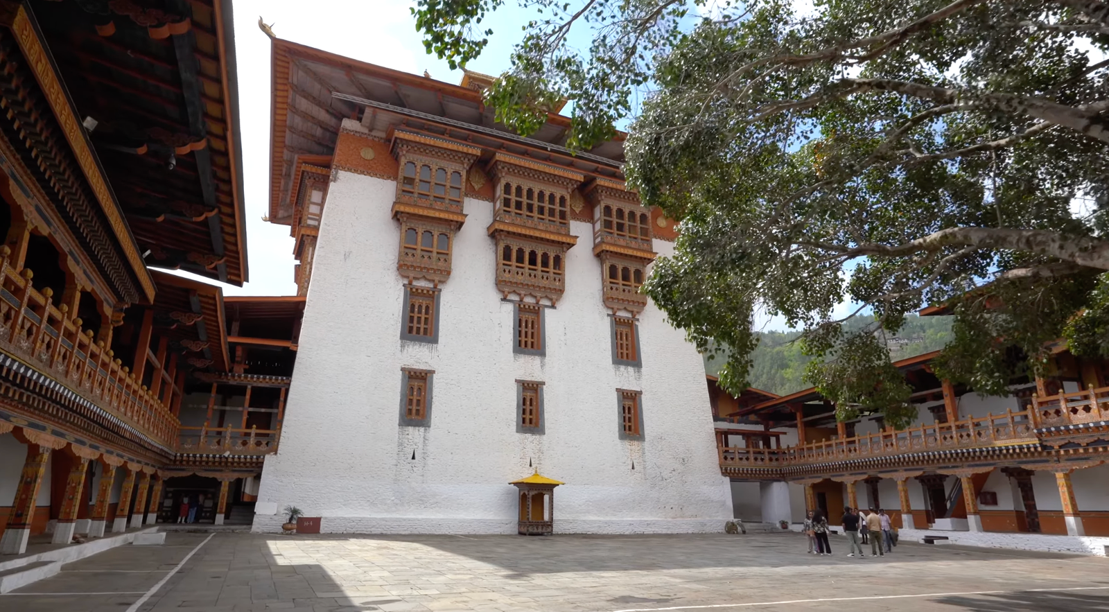
Punakha Dzong is genuinely the single most beautiful sightseeing stop of this entire leg. Mo Chhu, the female river, and Pho Chhu, the male river, meet just half a kilometre apart here and become the Puna Tsang Chhu, the confluence itself visible right beneath the Dzong. The complex now functions as an administration office and monastic school, and its central ground hosts a February Tshechu festival. The monastery itself is a wooden structure with brass pillars, early-17th-century murals tracing Buddha’s life from birth to enlightenment, lightly renovated since, and idols of both Guru Padmasambhava and Zhabdrung Ngawang Namgyal inside. Punakha itself served as Bhutan’s capital until roughly 50 years ago, before that role shifted to Thimphu.
One detail genuinely surprised me: once a year, on the third day of the festival, a pulley system built into the central block unfurls a massive applique thangka that covers the entire white section of the building, a piece of engineering and craftsmanship I hadn’t expected to find built into a 17th-century structure. The Suspension Bridge nearby, 200 metres long over the Pho Chhu, is worth the ten-minute detour on its own, sunny the day I crossed it but windy enough to notice.
A Genuinely Excellent Lunch and the Suspension Bridge
URD Restaurant, right opposite the Dzong, put together a spread I’d specifically requested after buying the ingredients myself on the drive in: Damroo Jaju, Pacha Jaju (a cane shoot and cheese soup), a chutney made from a local leaf called Cretey, a wild flower dish cooked with onion and tomato, Wild Asparagus, and Kashala Meto, a seasonal vegetable with a genuinely unique juicy taste that’s neither sweet nor sour. Namna and Fiddlehead Fern rounded things out, and the Damroo soup carried a flavour close to spring onion. One thing worth knowing: this same spicy local leaf used in the chutney was historically eaten more often than chilli itself in this region, chilli came later. Cane shoot took a few tries to properly appreciate, cooked in cheese it’s noticeably less bitter than I expected going in.
Rafting on the Mo Chhu and Pho Chhu
The rafting point sits about 10km outside Punakha, and while I didn’t raft myself, the setup is easy to size up from the bank, a suspension bridge overhead if you just want photos of the current. Mo Chhu, the gentler female river, is genuinely safe for families and children, ₹10,000 for a roughly 10km, hour-long run. Pho Chhu, the male river, runs Rapid Level 3, considerably more adventurous, ₹20,000 to 25,000 depending on season and demand.
Mr. KK, who runs a tour and travel agency based in Thimphu, came all the way out to meet me here, three months after we’d first connected at an event in Delhi. He’d already been instrumental in this whole trip, the guide and driver I’d been travelling with came through his referral, and having him walk me through the rafting options in person was a genuinely generous gesture on top of everything else he’d already helped arrange. If a proper hike appeals more than water, Khamsum Yulley Namgyal Chorten is a roughly 2-hour round trip from the same area, though I didn’t take it on this visit.
Phobjikha Valley and the Black-Necked Cranes
Phobjikha sits at roughly 2,900 to 3,000 metres, and it’s genuinely one of the more thoughtfully protected places I visited in Bhutan. Black-necked Cranes, an endangered species, migrate here between October and February, and a small information centre, ₹200 entry, keeps two rescued cranes in an aviary, one with a leg injury, one with wing damage, both saved from street dogs by villagers before being brought in. The single most striking thing about the whole valley: there are no overhead electric poles anywhere, wiring is buried specifically to protect the cranes, a level of environmental commitment I hadn’t seen built into infrastructure quite this directly before.
The Phobjikha Nature Trail, a 2km hike, runs through a mountain pony pasture before moving into a genuinely beautiful pine forest stretch, gaps between the trees opening onto valley views from a few different angles. Easy grade throughout, and bring binoculars if birdwatching is any part of your interest, this valley rewards it.
Pele La Pass to Trongsa
The drive to Trongsa runs about 3 hours non-stop, though sightseeing along the way makes that number mostly theoretical. Pele La Pass, at 3,100 metres, is a genuine birdwatching spot, a few people with serious camera lenses were already set up when we arrived. A gompa over 100 years old, its design drawing visibly from Nepal, sits along the route too, and a stop at the Nakey Chhu river turned into an unplanned shoe change after I got a foot properly wet, worth it anyway for a completely empty stretch of riverbank with no other tourists in sight.
Trongsa Dzong: Bhutan’s Largest
Trongsa Dzong, ₹500 entry, was built in 1644 specifically to unify Eastern Bhutan, and it’s genuinely the largest Dzong in the country, widely considered the most beautiful too. A huge Cypress tree, Bhutan’s national tree, guards the entrance, complete with an active hornet nest, worth giving proper space to since a hornet sting here is considerably worse than a honeybee’s.
Twenty-eight temples sit inside a structure that took more than a century to fully build, entirely wooden, interlocking joinery with no nails, partially renovated in 1927 using slaked lime, mud, and stone. The murals date to the original 1644 construction: a Cosmology Mandala shown from an aerial perspective, a Copper Mountain Paradise of the Second Buddha painting, and a Four Directional Kings mural among them. From an upper viewpoint, the Mangde Chhu, glacial meltwater, is visible winding through the valley below, a clearer view than the one I’d caught from further away earlier in the drive. Trongsa was the overnight stop before the final leg to Bumthang, roughly 2.5 hours further and the last stretch of this whole trip.
Practical Info at a Glance
| Phobjikha altitude | ~2,900–3,000 metres (9,500–9,800 feet) |
| Black-necked Crane season | October through February |
| Rafting (Mo Chhu / Pho Chhu) | ~₹10,000 (easy, family-friendly) / ~₹20,000–25,000 (Rapid Level 3) |
| Trongsa Dzong entry | ₹500; Bhutan’s largest Dzong, 28 temples inside |
Common Questions
When is the best time to see the black-necked cranes in Phobjikha?
October through February, when they migrate here from the Tibetan plateau. Outside that window, the valley is still worth visiting for the hike and the scenery.
Why does Phobjikha have no overhead power lines?
Electric wiring is buried underground throughout the valley specifically to protect the endangered black-necked cranes that winter there.
Is rafting in Punakha safe for families?
Yes, on the Mo Chhu specifically, an easy, gentle flow suitable for children. The Pho Chhu is a genuinely different, more adventurous experience, Rapid Level 3.
Why was Trongsa Dzong built specifically?
To unify Eastern Bhutan in 1644. It remains the country’s largest Dzong and is widely considered its most beautiful.
This is the fourth of five posts covering the full Bhutan trip. Catch up on Thimphu: Buddha Dordenma, a Living Museum, and Cheese Every Day, Bhutan: The Snow That Cancelled Haa Valley, and Tiger’s Nest: 245 Steps, a Dizzy Spell, and a Festival, or finish the series with Bumthang: A Lake That Burns and Bhutan’s Cultural Heartland.
Planning something similar?
Email your route and I’ll reply with honest, first-hand advice, no fluff.
Ask Dhruval →